


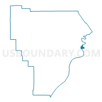
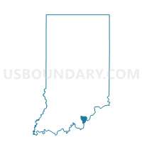
NEW ALBANY 15, Floyd County, Indiana
About
Outline

Summary
| Unique Area Identifier | 577118 |
| Name | NEW ALBANY 15 |
| County | Floyd County |
| State | Indiana |
| Area (square miles) | 0.23 |
| Land Area (square miles) | 0.22 |
| Water Area (square miles) | 0.01 |
| % of Land Area | 95.83 |
| % of Water Area | 4.17 |
| Latitude of the Internal Point | 38.31030360 |
| Longtitude of the Internal Point | -85.79441170 |
Maps

Graphs
Select a template below for downloading or customizing gragh for NEW ALBANY 15, Floyd County, Indiana


Neighbors
Neighoring Voting District (by Name) Neighboring Voting District on the Map
- JEFFERSONVILLE 27, Clark County, IN
- JEFFERSONVILLE 37, Clark County, IN
- NEW ALBANY 09, Floyd County, IN
- NEW ALBANY 14, Floyd County, IN
- NEW ALBANY 40, Floyd County, IN